Health & Fitness
Nassau County’s Special Districts and Service Providers Mapped
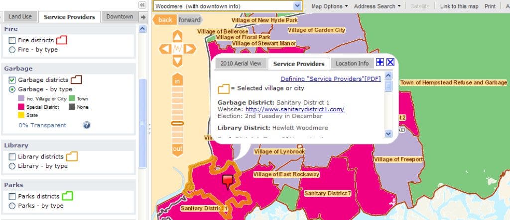
Visitors to www.longislandindexmaps.org are able to search by street address or village to view any or all of the 240 service providers in Nassau County.
The Long Island Index, in collaboration with the Center for Urban Research at the CUNY Graduate Center, has launched a new tool on its website (www.longislandindexmaps.org) that for the first time provides public access to maps representing the profusion of special districts that exist within Nassau County’s villages and towns.
Visitors to the site are now able to search by street address or village to view any or all of the 240 fire, sanitation, water, library, parks, parking, police, school and sewer districts – as well as areas where local, county, or state government provides these services – and see clearly who provides what services and where.
This new tool is the result of a comprehensive project to delineate all service provider boundaries using computer-mapping software, which integrates data on special districts from multiple sources. The maps are intended to give taxpayers and service providers a common and consistent basis for discussing special district issues.
Find out what's happening in Farmingdalewith free, real-time updates from Patch.
Want to know how many different entities provide water services in Nassau County and their exact boundaries? Well, now you can see them. Want to know who provides water services in your community? Want to know how they are organized, which are special districts, which are town services? You can find that too. With the click of the mouse you can find the contact information and election data for all the service providers for your property. “This is the kind of tool we were looking for when we first started studying how services are provided on Long Island,” said Ann Golob, director of the Long Island Index. “It didn’t exist so we took on the effort and have worked for over two years to collect, analyze and digitize this information. I think it will be a tremendous resource for the region.“
Also available on the site is a report by the Center for Governmental Research (CGR) in Rochester that explains the historical context surrounding the founding of special districts on Long Island along with the issues associated with so many providers. The CGR report, and an Excel spreadsheet of the data found on the maps (provider names, URL, contact information, election data) can be downloaded from the either the Index Web site or the interactive maps site.
Find out what's happening in Farmingdalewith free, real-time updates from Patch.
Steven Romalewski, director of the CUNY Mapping Service at the Center for Urban Research, said: “The maps bring a new level of information which will be a valuable resource for anyone trying to understand how special districts affect them. To create the service provider maps, we used raw data from the Nassau County assessor’s office, worked with the Index to validate the information independently, and reviewed additional data such as printed maps, historical metes and bounds, and some boundary maps in computer format from Nassau County. The online navigation is quick and easy with dynamic tools such as transparencies and map layers that combine seamlessly with the existing demographic, land use, and transportation data on the site.”
The site also features a detailed glossary of terms to help people understand the complex nature of different special districts across the county. For example, within the 54 library districts in Nassau County, there are four types: an Association Library, a School District Public Library, a Special District Public Library, and a Public Village Library. The glossary explains how each of these were established, how they are funded, bonding authority, if employees are subject to civil service law, and to what extent the community can be involved.
According to Long Island Association President Kevin Law, “These maps give Long Islanders a fantastic new tool for understanding the complexities that exist within our numerous special districts. It is really the first time that we can see who has what and where. It provides an opportunity to think out of the box about consolidation, which has the potential to improve efficiencies and stabilize taxes. People are only going to be supportive of this kind of initiative if they understand what is going on and these maps clearly show how multiple layers of government are a challenge for Long Island.”
“Civic organizations trying to research special districts in their own communities now have a powerful resource that never existed before,” said Nancy Douzinas, President of the Rauch Foundation and Publisher of the Long Island Index. “These maps will undoubtedly be of significant assistance to community groups, government agencies, private businesses and anyone else interested in Long Island’s communities.” In addition to the support from the Rauch Foundation, the Hagedorn Foundation helped support the initial mapping work leading to this project.
The Long Island Index plans to incorporate Suffolk County’s special districts in the coming months. The Long Island Index special district mapping feature is accessible at www.longislandindexmaps.org.
About the Rauch Foundation: The Long Island Index is funded by the Rauch Foundation, a family foundation headquartered in Garden City. In addition to funding the Long Island Index for nine years the Rauch Foundation commissioned The Long Island Profile Report and a series of polls on Long Island to determine how the region is faring. The Long Island Index 2004, Long Island Index 2005, Long Island Index 2006, Long Island Index 2007, Long Island Index 2008, Long Island Index 2009, Long Island Index 2010, Long Island Index 2011 and the Long Island Index 2012 are all available for download at www.longislandindex.org. The Long Island Index interactive maps, an online resource with detailed demographic, residential, transportation and educational information as well as the new Build a Better Burb website, are, also accessible from the Index’s website.
About the Center for Urban Research: Working with CUNY Graduate Center faculty and students, the Center for Urban Research (CUR) organizes basic research on the critical issues that face New York and other large cities in the U.S. and abroad, collaborates on applied research with public agencies, nonprofit organizations, and other partners, and holds forums for the media, foundations, community organizations and others about urban research at the Graduate Center and the City University. The CUNY Mapping Service at CUR assists organizations in realizing the geographic and mapping dimensions of their activities. The Center’s website is www.urbanresearch.org.
About CUNY Graduate Center: The Graduate Center is the doctorate-granting institution of The City University of New York (CUNY). An internationally recognized center for advanced studies and a national model for public doctoral education, the school offers more than thirty doctoral programs, as well as a number of master’s programs. Many of its faculty members are among the world’s leading scholars in their respective fields, and its alumni hold major positions in industry and government, as well as in academia. The Graduate Center is also home to 28 interdisciplinary research centers and institutes focused on areas of compelling social, civic, cultural, and scientific concerns. Located in a landmark Fifth Avenue building, The Graduate Center has become a vital part of New York City’s intellectual and cultural life with its extensive array of public lectures, exhibitions, concerts and theatrical events. Further information on the Graduate Center and its programs can be found at www.gc.cuny.edu


